Indonesian Moon
Part Two
![]()
"The
smallness of the villages and fields were to give a perspective on the
enormity of the volcanic mountain we were about to enter."
![]()
Now that sounds like a case of
clear-cut authorization to me. So on this beautiful clear Balinese morning
we took off for Rinjani. The Area Control cleared us up to our requested
11,000 feet and during the 30 minutes it took us to reach the volcano I
leafed through the POH. The only relevant section I was concerned about
was the settings for Take-off Power. I quickly found out that the charts,
contrary to what one pilot had said, did go up to and beyond 7,000 feet.
(Not that I was about to let a little extrapolation get in my way.) In
fact, the charts claimed that we would be able to get full power, i.e.,
675 hp, on takeoff.
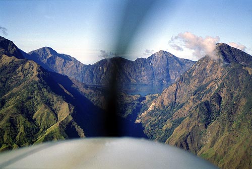
As the Rinjani volcano was along our normal
flight path from Bali to the luxury resort island of Amanwana, run by the
Aman resort group, I had surveyed the lake many times before. So this
morning I knew what I had to do. I approached the crater from west to east
and flew past the northern side. That put the V shaped cleft where the
overflow from the lake spills out as a waterfall on my right (starboard)
side. The tops of the V were varied from 9,000 ft on the west to 10,000 ft
high on the east climbing toward the 12,296 ft pinnacle, while the bottom
of the V was at the lake level of approximately 6,300 feet. That V shaped
“cut” made up my entrance.
I could have spiraled down from the
top of the crater rim, but I was planning for the dramatic. I wanted the
entrance into the crater to be a grand entrance and flying through the
relative narrowness of the “cut” into the enormity of the “basin”
would be like flying into another world and another time. “Ladies and
Gentleman, this is your Captain speaking; we have just left the present
and returned to the beginning of time.”
I flew past the cut and the waterfall at
about 10,000 ft and did a slow left descending turn, away from the volcano
and over the numerous terraced rice fields far below. The smallness of the
villages and fields were to give a perspective on the enormity of the
volcanic mountain we were about to enter. I descended to 8,000 ft and
finished my 270 degree turn facing due south straight into the V
shaped entrance. From this vista we could see the lake nestled inside the
cone. It looked small and I really had to fight the illusion that the
crater basin would be too small to circle inside. Proximity claustrophobia
began to set it. That is when you are flying between mountains and the
canyon walls seem to be closing in when in fact they are not. If you panic
you will attempt to turn when you should keep going straight ahead.
In the turn I had slowed the aircraft down
to 120 knots and before I entered the crater I selected 10 degrees of
flaps and slowed to 105 knots. Slowing down gives the passengers a better
view and lowering the flaps me a better view over the nose. As we entered
I banked and turned right to follow the rim just below the edge, giving
the sensation of being inside the basin without getting too low too
quickly. Once inside I started a slow left turn passing the 12,296 ft peak
on my right and placing the 7,838 ft Gunung Barujari secondary daughter
cone on my left.
We
were still in a left hand turn banking wing low over the crater of the
daughter cone allowing us to have a good look inside the vent.
We could see the steam and smoke rising from the still active
cone.
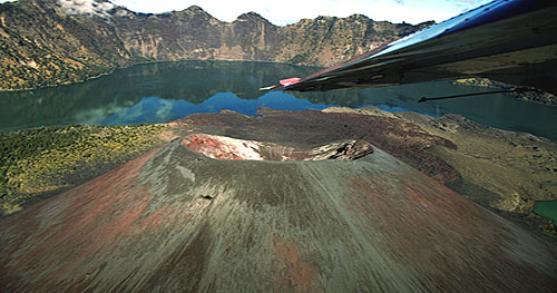
In fact, when we entered the main
crater Alex startled me by hollering, “Look, the volcano is erupting.”
Just below the daughter cone was a large fresh flow of lava differentiated
by the older flows by the blackness of the lava and by the fact there was
no vegetation growing on it. It was indeed a new flow in volcano time, but
that was 8 years ago already in our time. Alex was convinced that it had
happened since our last over flight on the way to the resort the day
before. I said that if it was recent the water would be boiling and
steaming.
“Oh, yeah,” he admitted.
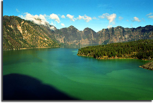
As we circled I had a good look at the
water. My first concern was of course the depth. With the water sitting in
an expansive cereal-bowl like hole, you don’t have to be a geologist to
extrapolate that the lake would be deep, possibly very deep… reportedly
nearly 800 ft deep. If I landed anywhere away from the crater sides I
would have deep water. Besides I could readily see to untold depths in the
relatively clear water.
I admit, though, I was slightly concerned
that the water might have been contaminated with sulfate or chloride,
which are both corrosive and which can both be found in volcanic waters if
the area is active. The water, however, looked like any mountain lake in
the Canadian Rockies. The water was a slightly opaque blue green that
appeared clear despite the obvious dissolved minerals obscuring the light
transmission.
The real clue as to the safety of the water
was the colour and health of the trees near the shore. Even from 2000 feet
I could see that the trees growing along the waters edge were a healthy
green, and not yellow as they would be if the water had turned poisonous.
Moreover the trees acted as our “canary” sentinels that if there had
been any recent serious chemical activity then the vent would have been
issuing carbon dioxide killing the nearby trees. There were no dead trees.
As I passed between the peak on my right
and the daughter cone on my left I set up for my final approach. Flying
once around the inside of the rim was partly for effect, but it also
served a useful purpose. It allowed me to gauge a feel for the winds that
might have been bowling over and around the peak that would affect my
final approach. This morning, and I suspect most mornings, it was dead
calm. In fact, I would be contending with glassy calm. The fly around also
allowed me time to gain perspective on distance and height.
I flew past the entrance, which was also to
be our exit, and over the open water of the main body of the lake and made
a tight 40 degree bank to the left swinging around to the backside of
the daughter cone again. The 180 degree turn served two purposes. For
one, it allowed the passengers on the right side of the aircraft (that is
when and if we ever flew passengers into the crater) to have a look inside
the active cone and secondly allowed me to set up for a full flap
descending final with a slow right turn directly onto the main body of the
lake. Dropping down low over the backside of the active cone allowed us to
spot the many steaming vents and hot springs that we had not seen from
higher up.
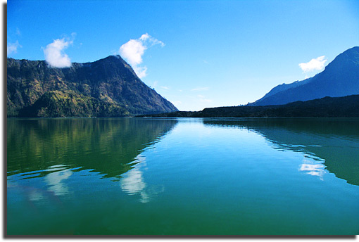
It was only as I came onto final did
I realize how big the crater and associated lake really was. I knew the
lake was something like five kilometers long, but confined inside the caldera’s rim it had
looked small. In fact, without proper reference I would have said it was
too small to take-off from. The problem was in attempting to find a
perspective to judge actual distances and relative sizes. A cliff or rock
can be large or small. A tree can be large or dwarfed. The water had no
perspective value and the air was so severe clear at this time in the
morning I could not judge distances properly. In essence I had no
reference. I did not even know the actual water level and with glassy
water how would I know to round off before taking a nosedive? I can see
why the other pilots had held off. Every survival instinct told me to
abort and go around. So according to my plan I did just that.
My plan was to get down as close to the
outside shore as possible and use the shoreline as a reference to my
height above the water while reading the actual altitude. This worked fine
except getting my reference was still difficult. With the assumption that
the trees inside a 7,000 to 10,000 ft crater would be stunted and small, I
kept thinking I was close to the shore when I was not close at all. It
took some concentration and conscience effort to get myself to fly the
aircraft closer and closer to the near vertical cliff face shoreline to be
able to properly judge my height above the water. When I did get close I
realized that the trees were a lot larger than I had imagined. No wonder
my perspective was thrown so far off.
Once I worked out the water’s altitude I
turned out toward the main body of the lake, skimmed the water with my
floats, and headed toward the cleft in the crater rim. The landing/takeoff
area could not have been blessed any more perfect. The area I chose was 1)
the longest straight stretch on the lake, 2) into any wind that would come
up later in the morning, 3) in the direction of the hiker’s camping site
if we ever wanted to go ashore and finally 4) facing straight toward the
exit for both the takeoff and for any necessary go around.
As this was my practice “go around” and
also simulated takeoff (without actually committing myself) I waited until
about half way down the lake and then applied full power. Alex was waiting
to take the readings of ITT (turbine temperature) and rate of climb. From
6,300 ft we eventually climbed to 8,000 ft with less than 740 degrees
Celsius
on the ITT (within the green) and over 500 ft per minute climb. Both well
within acceptable limits. At 500 ft above the lake level I pulled the
power slightly and headed out the exit to visualize what the escape would
feel like. I could have stayed inside the basin and spiral climbed my way
out of the top, but flying through the narrow walls of the cut was again a
way to feel the transition with a dramatic flare.
Exiting through the cut we flew right over
the hiker’s camping site, the hot springs, and the falls, and then the
landscape dropped away. You could feel the rush as the earth left you
suspended. We climbed just enough to make an “operations normal”
report to the Area Control frequency and then I banked left and headed
back inside. I did another approach and this time followed up with a full
stop landing. Landing in that clear mountain water was like landing on a
mirror. Struggling with spatial disorientation I felt like we were still
suspended in air as I could see the reflections of trees and rocks and
clouds below me.
Article and Images by John S Goulet
![]()
The attitude indicator will guide you back to Knowledge Based Stories.
 Top of this story.
Last modified on
June 15, 2006 .
© Virtual Horizons, 1996.